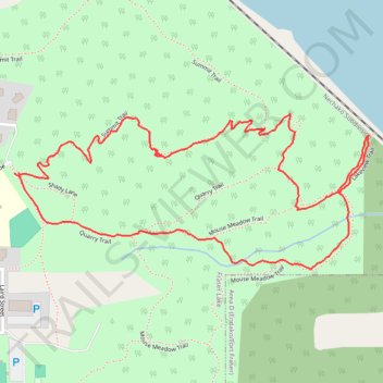
Mouse Mountain Park : summit, lakeview, meadow and quarry trails loop
- Distance: 1.7 mi
- Elevation gain: 137 m
- Maximum elevation: 807 m
- Elevation loss: 138 m
- Minimum elevation: 678 m
- Moving time: 52 m 38 s
- Moving speed: 1.9 mph
- Maximum speed: 5.5 mph
- Total time: 1 h 23 m
- Global speed: 1.2 mph
Interactive trail map
Trail profile
- Distance: 1.7 mi
- Elevation gain: 137 m
- Maximum elevation: 807 m
- Elevation loss: 138 m
- Minimum elevation: 678 m
- Moving time: 52 m 38 s
- Moving speed: 1.9 mph
- Maximum speed: 5.5 mph
- Total time: 1 h 23 m
- Global speed: 1.2 mph
About this trail
Name: Mouse Mountain Park : summit, lakeview, meadow and quarry trails loop trail, distance, elevation, map, profile, GPS track
Coordinates: 54.05906 -124.83675 54.06203 -124.82517