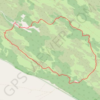
Deliblatska peščara: Bracina staza
- Distance: 7.6 mi
- Elevation gain: 97 m
- Maximum elevation: 148 m
- Elevation loss: 97 m
- Minimum elevation: 106 m
- Moving time: 3 h 29 m
- Moving speed: 2.2 mph
- Maximum speed: 3.2 mph
- Total time: 3 h 34 m
- Global speed: 2.1 mph
Interactive trail map
Trail profile
- Distance: 7.6 mi
- Elevation gain: 97 m
- Maximum elevation: 148 m
- Elevation loss: 97 m
- Minimum elevation: 106 m
- Moving time: 3 h 29 m
- Moving speed: 2.2 mph
- Maximum speed: 3.2 mph
- Total time: 3 h 34 m
- Global speed: 2.1 mph
About this trail
Name: Deliblatska peščara: Bracina staza trail, distance, elevation, map, profile, GPS track
Coordinates: 44.83280 21.08803 44.85852 21.13784
Other hiking, mountain biking, running and outdoor activity trails
Click on a trail to view its statistics, map and profile.
2022_Yu
Slovenia > Ajdovščina > Žapuže
Distance: 1,526.9 mi • Elevation gain: 32,048 m • Maximum elevation: 1,950 m