Make a donation
Gear up for your next adventure:
As an Amazon Associate, this site earns from qualifying purchases at no extra cost to you.
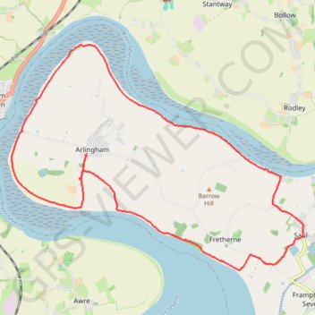
Arlingham Loop
- Distance: 11.2 mi
- Elevation gain: 71 m
- Maximum elevation: 24 m
- Elevation loss: 71 m
- Minimum elevation: 5 m
- Moving time: 3 h 53 m
- Moving speed: 2.9 mph
- Maximum speed: 6.1 mph
- Total time: 4 h 55 m
- Global speed: 2.3 mph
Interactive trail map
Make a donation
Gear up for your next adventure:
As an Amazon Associate, this site earns from qualifying purchases at no extra cost to you.
Trail profile
- Distance: 11.2 mi
- Elevation gain: 71 m
- Maximum elevation: 24 m
- Elevation loss: 71 m
- Minimum elevation: 5 m
- Moving time: 3 h 53 m
- Moving speed: 2.9 mph
- Maximum speed: 6.1 mph
- Total time: 4 h 55 m
- Global speed: 2.3 mph
Make a donation
Gear up for your next adventure:
As an Amazon Associate, this site earns from qualifying purchases at no extra cost to you.
About this trail
Name: Arlingham Loop trail, distance, elevation, map, profile, GPS track
Coordinates: 51.77608 -2.44596 51.81430 -2.36617
Topography: Gloucestershire topographic map, elevation, terrain
Make a donation
Gear up for your next adventure:
As an Amazon Associate, this site earns from qualifying purchases at no extra cost to you.
Other hiking, mountain biking, running and outdoor activity trails
Click on a trail to view its statistics, map and profile.
Stonehouse to Frampton
United Kingdom > England > Gloucestershire > Stonehouse
Distance: 11.3 mi • Elevation gain: 88 m • Maximum elevation: 37 m
Frampton On Severn Loop Walk
United Kingdom > England > Gloucestershire > Stroud > Frampton on Severn > Church End
Distance: 4.5 mi • Elevation gain: 27 m • Maximum elevation: 21 m
Frampton on Severn loop walk
United Kingdom > England > Gloucestershire > Stroud > Frampton on Severn > Church End
Distance: 8.7 mi • Elevation gain: 49 m • Maximum elevation: 21 m
Arlingham Loop Walk
United Kingdom > England > Gloucestershire > Stroud > Arlingham
Distance: 8.4 mi • Elevation gain: 71 m • Maximum elevation: 40 m
Make a donation
Gear up for your next adventure:
As an Amazon Associate, this site earns from qualifying purchases at no extra cost to you.
Dean2023-311
United Kingdom > England > Oxfordshire > Oxford
Distance: 192.8 mi • Elevation gain: 3,366 m • Maximum elevation: 290 m