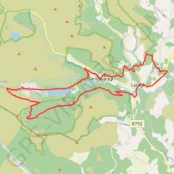
Moonlight Challenge
- Distance: 16.1 mi
- Elevation gain: 975 m
- Maximum elevation: 506 m
- Elevation loss: 974 m
- Minimum elevation: 126 m
- Moving time: 5 h 49 m
- Moving speed: 2.8 mph
- Maximum speed: 4.6 mph
- Total time: 6 h 41 m
- Global speed: 2.4 mph
Interactive trail map
Trail profile
- Distance: 16.1 mi
- Elevation gain: 975 m
- Maximum elevation: 506 m
- Elevation loss: 974 m
- Minimum elevation: 126 m
- Moving time: 5 h 49 m
- Moving speed: 2.8 mph
- Maximum speed: 4.6 mph
- Total time: 6 h 41 m
- Global speed: 2.4 mph
About this trail
Name: Moonlight Challenge trail, distance, elevation, map, profile, GPS track
Coordinates: 52.99258 -6.39830 53.02223 -6.27549
Other hiking, mountain biking, running and outdoor activity trails
Click on a trail to view its statistics, map and profile.
The Glendalough Hike - Wicklow Mountains National Park
Ireland > County Wicklow > Bookey Bridge
Distance: 11.7 mi • Elevation gain: 636 m • Maximum elevation: 503 m
Derrybawn Mountain Loop
Distance: 8.0 mi • Elevation gain: 448 m • Maximum elevation: 466 m
Glenealo Valley
Distance: 16.0 mi • Elevation gain: 937 m • Maximum elevation: 504 m