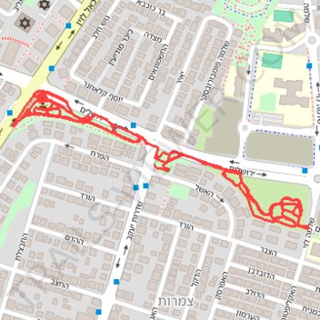
גן ירושלים וגנים ליד
- Distance: 3.3 mi
- Elevation gain: 32 m
- Maximum elevation: 75 m
- Elevation loss: 33 m
- Minimum elevation: 61 m
- Moving time: 40 m 6 s
- Moving speed: 4.9 mph
- Maximum speed: 10.9 mph
- Total time: 42 m 37 s
- Global speed: 4.6 mph
Interactive trail map
Trail profile
- Distance: 3.3 mi
- Elevation gain: 32 m
- Maximum elevation: 75 m
- Elevation loss: 33 m
- Minimum elevation: 61 m
- Moving time: 40 m 6 s
- Moving speed: 4.9 mph
- Maximum speed: 10.9 mph
- Total time: 42 m 37 s
- Global speed: 4.6 mph
About this trail
Name: גן ירושלים וגנים ליד trail, distance, elevation, map, profile, GPS track
Start: Tzamarot, Rishon LeZion, Rehovot Subdistrict, Center District, 7546902, Israel (31.96054 34.82396)
Coordinates: 31.95882 34.82071 31.96164 34.82785