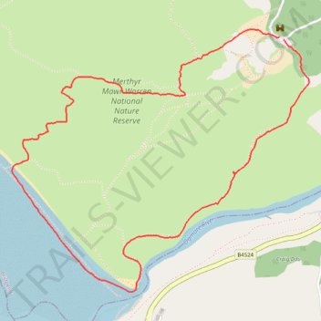
Hiking trail through Merthyr Mawr Sand dunes
Pen-Y-Bont Ar Ogwr Walking
- Distance: 3.4 mi
- Elevation gain: 83 m
- Maximum elevation: 71 m
- Elevation loss: 85 m
- Minimum elevation: 0 m
- Moving time: 1 h 49 m
- Moving speed: 1.9 mph
- Maximum speed: 2.9 mph
- Total time: 2 h 7 m
- Global speed: 1.6 mph
Interactive trail map
Trail profile
- Distance: 3.4 mi
- Elevation gain: 83 m
- Maximum elevation: 71 m
- Elevation loss: 85 m
- Minimum elevation: 0 m
- Moving time: 1 h 49 m
- Moving speed: 1.9 mph
- Maximum speed: 2.9 mph
- Total time: 2 h 7 m
- Global speed: 1.6 mph
About this trail
Name: Hiking trail through Merthyr Mawr Sand dunes trail, distance, elevation, map, profile, GPS track
Coordinates: 51.47000 -3.64775 51.48285 -3.62443
Topography: Bridgend County Borough topographic map, elevation, terrain