Sinnington MTB loop
- Distance: 14.2 mi
- Elevation gain: 464 m
- Maximum elevation: 276 m
- Elevation loss: 464 m
- Minimum elevation: 39 m
- Moving time: 2 h 11 m
- Moving speed: 6.4 mph
- Maximum speed: 24.4 mph
- Total time: 2 h 20 m
- Global speed: 6.1 mph
Interactive trail map
Trail profile
About this trail
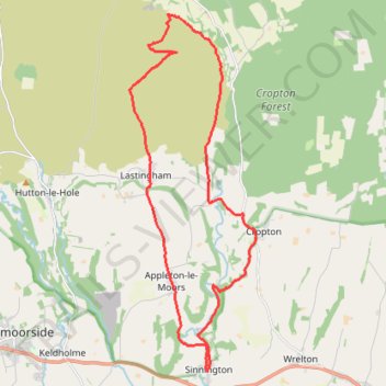
Name: Sinnington MTB loop trail, distance, elevation, map, profile, GPS track
Coordinates: 54.26182 -0.88776 54.33897 -0.84083
Topography: North Yorkshire topographic map, elevation, terrain
Other hiking, mountain biking, running and outdoor activity trails
Click on a trail to view its statistics, map and profile.
Lastingham MTB Loop
United Kingdom > England > North Yorkshire > Lastingham
Distance: 27.5 mi • Elevation gain: 1,046 m • Maximum elevation: 370 m
Farndale
United Kingdom > England > North Yorkshire > Appleton-le-Moors
Ryedale Mountain Biking
Distance: 32.9 mi • Elevation gain: 1,251 m • Maximum elevation: 407 m
Hartoft End Loop
United Kingdom > England > North Yorkshire
Ryedale Mountain Biking
Distance: 12.1 mi • Elevation gain: 421 m • Maximum elevation: 330 m