Thank you for supporting this site ❤️
Make a donation
Make a donation
Gear up for your next adventure:
As an Amazon Associate, this site earns from qualifying purchases at no extra cost to you.
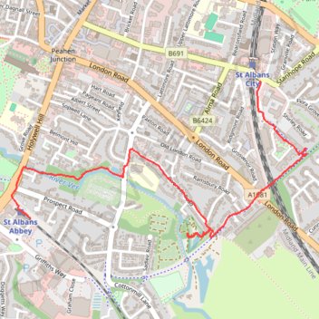
Colne Valley walk, St Albans
- Distance: 1.8 mi
- Elevation gain: 16 m
- Maximum elevation: 104 m
- Elevation loss: 36 m
- Minimum elevation: 76 m
- Moving time: 38 m 16 s
- Moving speed: 2.8 mph
- Maximum speed: 5.8 mph
- Total time: 38 m 16 s
- Global speed: 2.8 mph
Interactive trail map
Thank you for supporting this site ❤️
Make a donation
Make a donation
Gear up for your next adventure:
As an Amazon Associate, this site earns from qualifying purchases at no extra cost to you.
Trail profile
- Distance: 1.8 mi
- Elevation gain: 16 m
- Maximum elevation: 104 m
- Elevation loss: 36 m
- Minimum elevation: 76 m
- Moving time: 38 m 16 s
- Moving speed: 2.8 mph
- Maximum speed: 5.8 mph
- Total time: 38 m 16 s
- Global speed: 2.8 mph
Thank you for supporting this site ❤️
Make a donation
Make a donation
Gear up for your next adventure:
As an Amazon Associate, this site earns from qualifying purchases at no extra cost to you.
About this trail
Name: Colne Valley walk, St Albans trail, distance, elevation, map, profile, GPS track
Coordinates: 51.74363 -0.34306 51.74985 -0.32418
Topography: St Albans topographic map, elevation, terrain
Thank you for supporting this site ❤️
Make a donation
Make a donation
Gear up for your next adventure:
As an Amazon Associate, this site earns from qualifying purchases at no extra cost to you.
Other hiking, mountain biking, running and outdoor activity trails
Click on a trail to view its statistics, map and profile.
St Albans Green Ring
United Kingdom > England > Hertfordshire > St Albans
Distance: 4.0 mi • Elevation gain: 69 m • Maximum elevation: 128 m