Harmon Canyon Preserve
Morning Run
- Distance: 4.0 mi
- Elevation gain: 193 m
- Maximum elevation: 290 m
- Elevation loss: 192 m
- Minimum elevation: 134 m
- Moving time: 58 m 17 s
- Moving speed: 4.1 mph
- Maximum speed: 6.3 mph
- Total time: 58 m 17 s
- Global speed: 4.1 mph
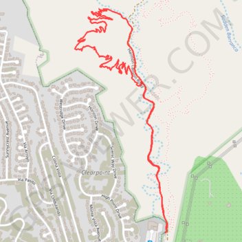
Interactive trail map
Trail profile
- Distance: 4.0 mi
- Elevation gain: 193 m
- Maximum elevation: 290 m
- Elevation loss: 192 m
- Minimum elevation: 134 m
- Moving time: 58 m 17 s
- Moving speed: 4.1 mph
- Maximum speed: 6.3 mph
- Total time: 58 m 17 s
- Global speed: 4.1 mph
About this trail
Name: Harmon Canyon Preserve trail, distance, elevation, map, profile, GPS track
Start: Harmon Canyon Road, Ventura County, California, 93004, United States (34.29044 -119.19742)
End: Harmon Canyon Road, Ventura County, California, 93004, United States (34.29052 -119.19731)
Coordinates: 34.29044 -119.20493 34.30577 -119.19728
Other hiking, mountain biking, running and outdoor activity trails
Click on a trail to view its statistics, map and profile.
Harmon Canyon Preserve
United States > California > Ventura County
Distance: 3.3 mi • Elevation gain: 137 m • Maximum elevation: 218 m