Stara planina: Senokos, vodopad Skok, Golemo guvno, Adžina k...
- Distance: 13.0 mi
- Elevation gain: 1,022 m
- Maximum elevation: 1,925 m
- Elevation loss: 1,022 m
- Minimum elevation: 957 m
- Moving time: 6 h 5 m
- Moving speed: 2.1 mph
- Maximum speed: 3.5 mph
- Total time: 7 h 51 m
- Global speed: 1.7 mph
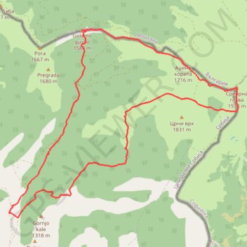
Interactive trail map
Trail profile
- Distance: 13.0 mi
- Elevation gain: 1,022 m
- Maximum elevation: 1,925 m
- Elevation loss: 1,022 m
- Minimum elevation: 957 m
- Moving time: 6 h 5 m
- Moving speed: 2.1 mph
- Maximum speed: 3.5 mph
- Total time: 7 h 51 m
- Global speed: 1.7 mph
About this trail
Name: Stara planina: Senokos, vodopad Skok, Golemo guvno, Adžina k... trail, distance, elevation, map, profile, GPS track
Coordinates: 43.16142 22.93103 43.20695 23.00665
Other hiking, mountain biking, running and outdoor activity trails
Click on a trail to view its statistics, map and profile.
Senokos-Pregrada-Mučibaba-Tupanac 2-Dobro jutro-Široke luke
Serbia > Central Serbia > Pirot Administrative District > Dimitrovgrad Municipality > Senokos
Distance: 12.5 mi • Elevation gain: 1,004 m • Maximum elevation: 1,728 m