Make a donation
Gear up for your next adventure:
As an Amazon Associate, this site earns from qualifying purchases at no extra cost to you.
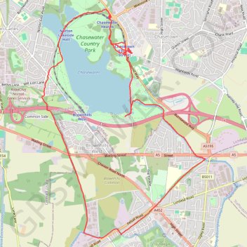
Chasewater Country Park circular all paths good
- Distance: 8.2 mi
- Elevation gain: 73 m
- Maximum elevation: 162 m
- Elevation loss: 73 m
- Minimum elevation: 144 m
- Moving time: 2 h 52 m
- Moving speed: 2.9 mph
- Maximum speed: 5.5 mph
- Total time: 3 h 24 m
- Global speed: 2.4 mph
Interactive trail map
Make a donation
Gear up for your next adventure:
As an Amazon Associate, this site earns from qualifying purchases at no extra cost to you.
Trail profile
- Distance: 8.2 mi
- Elevation gain: 73 m
- Maximum elevation: 162 m
- Elevation loss: 73 m
- Minimum elevation: 144 m
- Moving time: 2 h 52 m
- Moving speed: 2.9 mph
- Maximum speed: 5.5 mph
- Total time: 3 h 24 m
- Global speed: 2.4 mph
Make a donation
Gear up for your next adventure:
As an Amazon Associate, this site earns from qualifying purchases at no extra cost to you.
About this trail
Name: Chasewater Country Park circular all paths good trail, distance, elevation, map, profile, GPS track
Coordinates: 52.64417 -1.96266 52.67732 -1.92356
Topography: Lichfield topographic map, elevation, terrain
Make a donation
Gear up for your next adventure:
As an Amazon Associate, this site earns from qualifying purchases at no extra cost to you.
Other hiking, mountain biking, running and outdoor activity trails
Click on a trail to view its statistics, map and profile.
Lichfield Road to Queen Mary's Grammar School
United Kingdom > England > Brownhills
Distance: 5.9 mi • Elevation gain: 46 m • Maximum elevation: 154 m
Lichfield Road to United Kingdom
United Kingdom > England > Brownhills
Distance: 1.7 mi • Elevation gain: 7 m • Maximum elevation: 153 m
Lichfield Road to ALDI
United Kingdom > England > Brownhills
Distance: 0.2 mi • Elevation gain: 1 m • Maximum elevation: 152 m