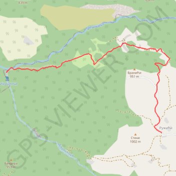
Track
- Distance: 2.1 mi
- Elevation gain: 301 m
- Maximum elevation: 935 m
- Elevation loss: 17 m
- Minimum elevation: 650 m
- Moving time: 52 m 31 s
- Moving speed: 2.4 mph
- Maximum speed: 3.6 mph
- Total time: 1 h 31 s
- Global speed: 2.1 mph
Interactive trail map
Trail profile
- Distance: 2.1 mi
- Elevation gain: 301 m
- Maximum elevation: 935 m
- Elevation loss: 17 m
- Minimum elevation: 650 m
- Moving time: 52 m 31 s
- Moving speed: 2.4 mph
- Maximum speed: 3.6 mph
- Total time: 1 h 31 s
- Global speed: 2.1 mph
About this trail
Name: Track trail, distance, elevation, map, profile, GPS track
Coordinates: 44.12914 19.58821 44.13795 19.61041
Other hiking, mountain biking, running and outdoor activity trails
Click on a trail to view its statistics, map and profile.
Vodopad Dubrašnica
Serbia > Central Serbia > Zlatibor Administrative District > Bajina Basta Municipality > Gvozdac > Ружићи
Distance: 6.4 mi • Elevation gain: 591 m • Maximum elevation: 939 m
Vodopadi Susice i Dubrasnice 01.11.2020.
Serbia > Central Serbia > Macva Administrative District > Ljubovija Municipality > Gornje Koslje > Доње Кошље
Distance: 6.4 mi • Elevation gain: 536 m • Maximum elevation: 915 m
Vodopadi Dubrasnice
Serbia > Central Serbia > Zlatibor Administrative District > Bajina Basta Municipality > Gvozdac > Ружићи
Distance: 5.2 mi • Elevation gain: 438 m • Maximum elevation: 970 m
2022_Yu
Slovenia > Ajdovščina > Žapuže
Distance: 1,526.9 mi • Elevation gain: 32,048 m • Maximum elevation: 1,950 m
Gornje Koslje - Tresnjica Gorge - Dubrasnica Waterfall - Pos...
Serbia > Central Serbia > Macva Administrative District > Ljubovija Municipality > Gornje Koslje
Distance: 7.6 mi • Elevation gain: 631 m • Maximum elevation: 917 m