Thank you for supporting this site ❤️
Make a donation
Make a donation
Gear up for your next adventure:
As an Amazon Associate, this site earns from qualifying purchases at no extra cost to you.
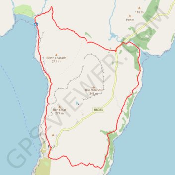
Elgol Halbinsel
- Distance: 11.3 mi
- Elevation gain: 546 m
- Maximum elevation: 189 m
- Elevation loss: 546 m
- Minimum elevation: 2 m
- Moving time: 5 h 33 m
- Moving speed: 2.0 mph
- Maximum speed: 3.8 mph
- Total time: 7 h 13 m
- Global speed: 1.6 mph
Interactive trail map
Thank you for supporting this site ❤️
Make a donation
Make a donation
Gear up for your next adventure:
As an Amazon Associate, this site earns from qualifying purchases at no extra cost to you.
Trail profile
- Distance: 11.3 mi
- Elevation gain: 546 m
- Maximum elevation: 189 m
- Elevation loss: 546 m
- Minimum elevation: 2 m
- Moving time: 5 h 33 m
- Moving speed: 2.0 mph
- Maximum speed: 3.8 mph
- Total time: 7 h 13 m
- Global speed: 1.6 mph
Thank you for supporting this site ❤️
Make a donation
Make a donation
Gear up for your next adventure:
As an Amazon Associate, this site earns from qualifying purchases at no extra cost to you.
About this trail
Name: Elgol Halbinsel trail, distance, elevation, map, profile, GPS track
Start: B8083, Kilmarie, Highland, Scotland, IV49 9AX, United Kingdom (57.17930 -6.06341)
End: B8083, Kilmarie, Highland, Scotland, IV49 9AX, United Kingdom (57.17929 -6.06340)
Coordinates: 57.14202 -6.11121 57.19378 -6.04901
Topography: Highland topographic map, elevation, terrain
Thank you for supporting this site ❤️
Make a donation
Make a donation
Gear up for your next adventure:
As an Amazon Associate, this site earns from qualifying purchases at no extra cost to you.