Stublo 2020. Jun. manastir Uvac-plan.dom
- Distance: 7.0 mi
- Elevation gain: 736 m
- Maximum elevation: 1,182 m
- Elevation loss: 737 m
- Minimum elevation: 506 m
- Moving time: 3 h 49 m
- Moving speed: 1.8 mph
- Maximum speed: 5.8 mph
- Total time: 7 h 7 m
- Global speed: 1.0 mph
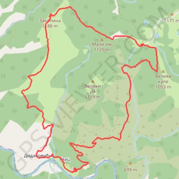
Interactive trail map
Trail profile
- Distance: 7.0 mi
- Elevation gain: 736 m
- Maximum elevation: 1,182 m
- Elevation loss: 737 m
- Minimum elevation: 506 m
- Moving time: 3 h 49 m
- Moving speed: 1.8 mph
- Maximum speed: 5.8 mph
- Total time: 7 h 7 m
- Global speed: 1.0 mph
About this trail
Name: Stublo 2020. Jun. manastir Uvac-plan.dom trail, distance, elevation, map, profile, GPS track
Coordinates: 43.61182 19.57834 43.63448 19.60401
Other hiking, mountain biking, running and outdoor activity trails
Click on a trail to view its statistics, map and profile.
2022_Yu
Slovenia > Ajdovščina > Žapuže
Distance: 1,526.9 mi • Elevation gain: 32,048 m • Maximum elevation: 1,950 m
Stublo - Kanjon Uvca - Manastir Dubrava
Serbia > Central Serbia > Zlatibor Administrative District > Cajetina Municipality > Омар
Distance: 13.2 mi • Elevation gain: 904 m • Maximum elevation: 1,130 m
Јабланица - Радов поток - Томов поток - Јабланица
Serbia > Central Serbia > Zlatibor Administrative District > Cajetina Municipality > Jablanica
Distance: 5.6 mi • Elevation gain: 741 m • Maximum elevation: 1,206 m
Stublo memorijalni uspon Aleksandar Džavić Planine zovu, pla...
Serbia > Central Serbia > Zlatibor Administrative District > Cajetina Municipality > Stublo
Distance: 9.6 mi • Elevation gain: 684 m • Maximum elevation: 1,299 m