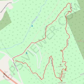
Salt Mountain Loop
- Distance: 2.5 mi
- Elevation gain: 272 m
- Maximum elevation: 231 m
- Elevation loss: 273 m
- Minimum elevation: 22 m
- Moving time: 1 h 32 m
- Moving speed: 1.7 mph
- Maximum speed: 4.0 mph
- Total time: 2 h 27 m
- Global speed: 1.0 mph
Interactive trail map
Trail profile
- Distance: 2.5 mi
- Elevation gain: 272 m
- Maximum elevation: 231 m
- Elevation loss: 273 m
- Minimum elevation: 22 m
- Moving time: 1 h 32 m
- Moving speed: 1.7 mph
- Maximum speed: 4.0 mph
- Total time: 2 h 27 m
- Global speed: 1.0 mph
About this trail
Name: Salt Mountain Loop trail, distance, elevation, map, profile, GPS track
Coordinates: 45.96386 -61.10433 45.97344 -61.09392
Other hiking, mountain biking, running and outdoor activity trails
Click on a trail to view its statistics, map and profile.
Antigonish - Whycocomagh
Canada > Nova Scotia > Town of Antigonish > Antigonish
Gulf of Saint Lawrence. Cape Breton Island. #Bike #Antigonish #Whycocomagh #SaintLawrence #CapeBreton
Distance: 64.6 mi • Elevation gain: 891 m • Maximum elevation: 135 m