Thank you for supporting this site ❤️
Make a donation
Make a donation
Gear up for your next adventure:
As an Amazon Associate, this site earns from qualifying purchases at no extra cost to you.
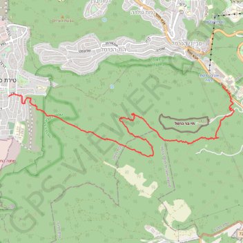
Secret path
- Distance: 5.8 mi
- Elevation gain: 181 m
- Maximum elevation: 455 m
- Elevation loss: 588 m
- Minimum elevation: 47 m
Interactive trail map
Thank you for supporting this site ❤️
Make a donation
Make a donation
Gear up for your next adventure:
As an Amazon Associate, this site earns from qualifying purchases at no extra cost to you.
Trail profile
- Distance: 5.8 mi
- Elevation gain: 181 m
- Maximum elevation: 455 m
- Elevation loss: 588 m
- Minimum elevation: 47 m
Thank you for supporting this site ❤️
Make a donation
Make a donation
Gear up for your next adventure:
As an Amazon Associate, this site earns from qualifying purchases at no extra cost to you.
About this trail
Name: Secret path trail, distance, elevation, map, profile, GPS track
Coordinates: 32.74742 34.97298 32.76017 35.02185
Thank you for supporting this site ❤️
Make a donation
Make a donation
Gear up for your next adventure:
As an Amazon Associate, this site earns from qualifying purchases at no extra cost to you.
Other hiking, mountain biking, running and outdoor activity trails
Click on a trail to view its statistics, map and profile.
Home78Rec
Israel > Haifa District > Nesher
Distance: 48.7 mi • Elevation gain: 1,479 m • Maximum elevation: 461 m