Thank you for supporting this site ❤️
Make a donation
Make a donation
Gear up for your next adventure:
As an Amazon Associate, this site earns from qualifying purchases at no extra cost to you.
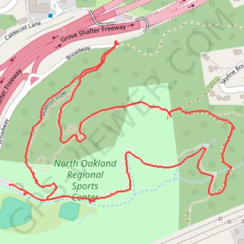
North Oakland sports center hike
Oakland Walking
- Distance: 1.9 mi
- Elevation gain: 121 m
- Maximum elevation: 311 m
- Elevation loss: 126 m
- Minimum elevation: 206 m
- Moving time: 34 m 12 s
- Moving speed: 3.3 mph
- Maximum speed: 10.8 mph
- Total time: 50 m 22 s
- Global speed: 2.3 mph
Interactive trail map
Thank you for supporting this site ❤️
Make a donation
Make a donation
Gear up for your next adventure:
As an Amazon Associate, this site earns from qualifying purchases at no extra cost to you.
Trail profile
- Distance: 1.9 mi
- Elevation gain: 121 m
- Maximum elevation: 311 m
- Elevation loss: 126 m
- Minimum elevation: 206 m
- Moving time: 34 m 12 s
- Moving speed: 3.3 mph
- Maximum speed: 10.8 mph
- Total time: 50 m 22 s
- Global speed: 2.3 mph
Thank you for supporting this site ❤️
Make a donation
Make a donation
Gear up for your next adventure:
As an Amazon Associate, this site earns from qualifying purchases at no extra cost to you.
About this trail
Name: North Oakland sports center hike trail, distance, elevation, map, profile, GPS track
Start: Caldecott Flow, Oakland, Alameda County, California, 94618, United States (37.84995 -122.22053)
End: Broadway, Oakland, Alameda County, California, 94618, United States (37.85030 -122.22182)
Coordinates: 37.84982 -122.22182 37.85418 -122.21414
Thank you for supporting this site ❤️
Make a donation
Make a donation
Gear up for your next adventure:
As an Amazon Associate, this site earns from qualifying purchases at no extra cost to you.