Djeravica - Gjeravica - Gusan - Circular ridge tour
- Distance: 8.8 mi
- Elevation gain: 1,239 m
- Maximum elevation: 2,638 m
- Elevation loss: 1,238 m
- Minimum elevation: 1,697 m
- Moving time: 5 h 14 m
- Moving speed: 1.7 mph
- Maximum speed: 5.5 mph
- Total time: 5 d 16 h
- Global speed: 0.1 mph
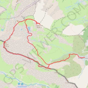
Interactive trail map
Trail profile
- Distance: 8.8 mi
- Elevation gain: 1,239 m
- Maximum elevation: 2,638 m
- Elevation loss: 1,238 m
- Minimum elevation: 1,697 m
- Moving time: 5 h 14 m
- Moving speed: 1.7 mph
- Maximum speed: 5.5 mph
- Total time: 5 d 16 h
- Global speed: 0.1 mph
About this trail
Name: Djeravica - Gjeravica - Gusan - Circular ridge tour trail, distance, elevation, map, profile, GPS track
Start: Gropa e Erenikut, Municipality of Junik, District of Gjakova, 51050, Kosovo (42.51957 20.16503)
End: Gropa e Erenikut, Municipality of Junik, District of Gjakova, 51050, Kosovo (42.51954 20.16507)
Coordinates: 42.51491 20.12123 42.53473 20.16507
Other hiking, mountain biking, running and outdoor activity trails
Click on a trail to view its statistics, map and profile.
2022_Yu
Slovenia > Ajdovščina > Žapuže
Distance: 1,526.9 mi • Elevation gain: 32,048 m • Maximum elevation: 1,950 m