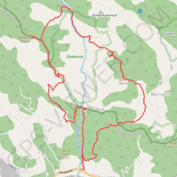
Tučkovo - Brdo Šest - Orovica
- Distance: 8.2 mi
- Elevation gain: 909 m
- Maximum elevation: 824 m
- Elevation loss: 910 m
- Minimum elevation: 303 m
- Moving time: 3 h 31 m
- Moving speed: 2.3 mph
- Maximum speed: 7.0 mph
- Total time: 5 h 59 m
- Global speed: 1.4 mph
Interactive trail map
Trail profile
- Distance: 8.2 mi
- Elevation gain: 909 m
- Maximum elevation: 824 m
- Elevation loss: 910 m
- Minimum elevation: 303 m
- Moving time: 3 h 31 m
- Moving speed: 2.3 mph
- Maximum speed: 7.0 mph
- Total time: 5 h 59 m
- Global speed: 1.4 mph
About this trail
Name: Tučkovo - Brdo Šest - Orovica trail, distance, elevation, map, profile, GPS track
Coordinates: 43.90015 20.12215 43.93017 20.15146
Other hiking, mountain biking, running and outdoor activity trails
Click on a trail to view its statistics, map and profile.
2022_Yu
Slovenia > Ajdovščina > Žapuže
Distance: 1,526.9 mi • Elevation gain: 32,048 m • Maximum elevation: 1,950 m