ITILAR034V50U8CA
- Distance: 5.5 mi
- Elevation gain: 397 m
- Maximum elevation: 351 m
- Elevation loss: 397 m
- Minimum elevation: 162 m
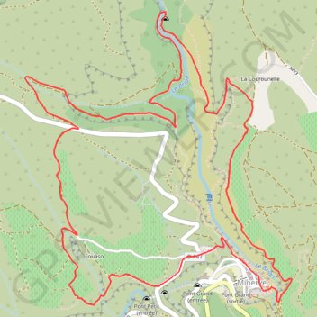
Interactive trail map
Trail profile
- Distance: 5.5 mi
- Elevation gain: 397 m
- Maximum elevation: 351 m
- Elevation loss: 397 m
- Minimum elevation: 162 m
About this trail
Name: ITILAR034V50U8CA trail, distance, elevation, map, profile, GPS track
Coordinates: 43.35266 2.72852 43.36933 2.74941
Other hiking, mountain biking, running and outdoor activity trails
Click on a trail to view its statistics, map and profile.
GR 10 - Traversée des Pyrénées
France > Occitania > Pyrénées-Orientales > Banyuls-sur-Mer
Distance: 543.6 mi • Elevation gain: 57,000 m • Maximum elevation: 2,599 m
1 LUCENA - MONTPELLIER
Distance: 1,842.0 mi • Elevation gain: 29,500 m • Maximum elevation: 1,048 m
Southern section — European Divide Trail
France > Auvergne-Rhône-Alpes > Drôme > Valence
Distance: 1,506.1 mi • Elevation gain: 42,375 m • Maximum elevation: 2,005 m
Chemin de Saint-Jacques-de-Compostelle
Switzerland > Geneva > Geneva
Distance: 694.6 mi • Elevation gain: 25,262 m • Maximum elevation: 1,430 m
Canal du Midi
France > Occitania > Haute-Garonne > Ramonville-Saint-Agne
Distance: 164.6 mi • Elevation gain: 1,078 m • Maximum elevation: 197 m