GOTOES Export
Created with GOTOES STRAVA TOOLS Version 22.9
- Distance: 54.0 mi
- Elevation gain: 1,316 m
- Maximum elevation: 1,071 m
- Elevation loss: 1,242 m
- Minimum elevation: 706 m
- Moving time: 4 h 55 m
- Moving speed: 11.0 mph
- Maximum speed: 36.2 mph
- Total time: 5 h 26 m
- Global speed: 9.9 mph
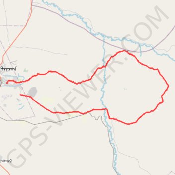
Interactive trail map
Trail profile
- Distance: 54.0 mi
- Elevation gain: 1,316 m
- Maximum elevation: 1,071 m
- Elevation loss: 1,242 m
- Minimum elevation: 706 m
- Moving time: 4 h 55 m
- Moving speed: 11.0 mph
- Maximum speed: 36.2 mph
- Total time: 5 h 26 m
- Global speed: 9.9 mph
About this trail
Name: GOTOES Export trail, distance, elevation, map, profile, GPS track
Start: Чулуун зам, Darkhan, Darkhan-Uul, 34000, Mongolia (49.46281 105.96436)
End: Хонгор ᠬᠣᠩᠭ᠋ᠤᠷ, Darkhan-Uul, 45040, Mongolia (49.43890 106.00534)
Coordinates: 49.38079 105.96436 49.52731 106.45945
Other hiking, mountain biking, running and outdoor activity trails
Click on a trail to view its statistics, map and profile.
GOTOES Export
Mongolia > Darkhan-Uul > Darkhan
Distance: 54.0 mi • Elevation gain: 1,316 m • Maximum elevation: 1,071 m
GOTOES Export
Mongolia > Darkhan-Uul > Darkhan
Created with GOTOES STRAVA TOOLS Version 22.9
Distance: 54.0 mi • Elevation gain: 1,316 m • Maximum elevation: 1,071 m