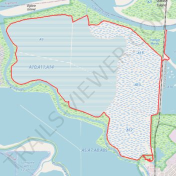
Alviso Slough Trail
- Distance: 10.7 mi
- Elevation gain: 52 m
- Maximum elevation: 3 m
- Elevation loss: 52 m
- Minimum elevation: -4 m
- Moving time: 1 h 52 m
- Moving speed: 5.7 mph
- Maximum speed: 10.9 mph
- Total time: 2 h 34 m
- Global speed: 4.1 mph
Interactive trail map
Trail profile
- Distance: 10.7 mi
- Elevation gain: 52 m
- Maximum elevation: 3 m
- Elevation loss: 52 m
- Minimum elevation: -4 m
- Moving time: 1 h 52 m
- Moving speed: 5.7 mph
- Maximum speed: 10.9 mph
- Total time: 2 h 34 m
- Global speed: 4.1 mph
About this trail
Name: Alviso Slough Trail trail, distance, elevation, map, profile, GPS track
Coordinates: 37.42966 -122.02004 37.46313 -121.97336
Other hiking, mountain biking, running and outdoor activity trails
Click on a trail to view its statistics, map and profile.
Guadalupe River Trail and various flooding detours, San Jose
United States > California > Santa Clara County > San Jose
Distance: 18.3 mi • Elevation gain: 79 m • Maximum elevation: 31 m