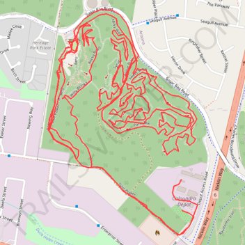
Sugar Bag Road Town Reserve Mountain Biking
Most of the trails #MTB
- Distance: 9.4 mi
- Elevation gain: 231 m
- Maximum elevation: 54 m
- Elevation loss: 231 m
- Minimum elevation: 9 m
- Moving time: 1 h 36 m
- Moving speed: 5.8 mph
- Maximum speed: 19.8 mph
- Total time: 2 h 43 m
- Global speed: 3.4 mph
Interactive trail map
Trail profile
- Distance: 9.4 mi
- Elevation gain: 231 m
- Maximum elevation: 54 m
- Elevation loss: 231 m
- Minimum elevation: 9 m
- Moving time: 1 h 36 m
- Moving speed: 5.8 mph
- Maximum speed: 19.8 mph
- Total time: 2 h 43 m
- Global speed: 3.4 mph
About this trail
Name: Sugar Bag Road Town Reserve Mountain Biking trail, distance, elevation, map, profile, GPS track
Coordinates: -26.79570 153.11245 -26.78549 153.12002
Other hiking, mountain biking, running and outdoor activity trails
Click on a trail to view its statistics, map and profile.
2026-07-14_02-27_Tue
Australia > Queensland > Brisbane
Distance: 252.4 mi • Elevation gain: 3,756 m • Maximum elevation: 171 m
Currimundi - Ewen Maddock Dam - Beerburrum
Australia > Queensland > Sunshine Coast Regional
Distance: 34.1 mi • Elevation gain: 445 m • Maximum elevation: 47 m