Thank you for supporting this site ❤️
Make a donation
Make a donation
Gear up for your next adventure:
As an Amazon Associate, this site earns from qualifying purchases at no extra cost to you.
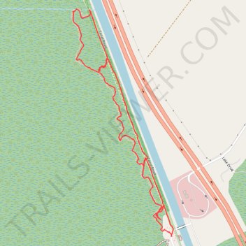
Canal Road and Supple Jack Trail Loop in Dismal Swamp State Park
- Distance: 2.1 mi
- Elevation gain: 12 m
- Maximum elevation: 11 m
- Elevation loss: 12 m
- Minimum elevation: 3 m
- Moving time: 43 m 35 s
- Moving speed: 2.9 mph
- Maximum speed: 10.8 mph
- Total time: 55 m 3 s
- Global speed: 2.3 mph
Interactive trail map
Thank you for supporting this site ❤️
Make a donation
Make a donation
Gear up for your next adventure:
As an Amazon Associate, this site earns from qualifying purchases at no extra cost to you.
Trail profile
- Distance: 2.1 mi
- Elevation gain: 12 m
- Maximum elevation: 11 m
- Elevation loss: 12 m
- Minimum elevation: 3 m
- Moving time: 43 m 35 s
- Moving speed: 2.9 mph
- Maximum speed: 10.8 mph
- Total time: 55 m 3 s
- Global speed: 2.3 mph
Thank you for supporting this site ❤️
Make a donation
Make a donation
Gear up for your next adventure:
As an Amazon Associate, this site earns from qualifying purchases at no extra cost to you.
About this trail
Name: Canal Road and Supple Jack Trail Loop in Dismal Swamp State Park trail, distance, elevation, map, profile, GPS track
Start: Camden County, North Carolina, United States (36.50507 -76.35607)
End: Camden County, North Carolina, United States (36.50517 -76.35606)
Coordinates: 36.50507 -76.36153 36.51520 -76.35597
Thank you for supporting this site ❤️
Make a donation
Make a donation
Gear up for your next adventure:
As an Amazon Associate, this site earns from qualifying purchases at no extra cost to you.