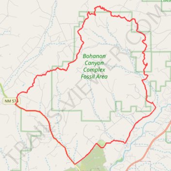
Mountain Biking - Bohanon Canyon Complex Fossil Area Loop
- Distance: 29.0 mi
- Elevation gain: 893 m
- Maximum elevation: 2,096 m
- Elevation loss: 893 m
- Minimum elevation: 1,736 m
- Moving time: 3 h 48 m
- Moving speed: 7.6 mph
- Maximum speed: 32.6 mph
- Total time: 4 h 15 m
- Global speed: 6.8 mph
Interactive trail map
Trail profile
- Distance: 29.0 mi
- Elevation gain: 893 m
- Maximum elevation: 2,096 m
- Elevation loss: 893 m
- Minimum elevation: 1,736 m
- Moving time: 3 h 48 m
- Moving speed: 7.6 mph
- Maximum speed: 32.6 mph
- Total time: 4 h 15 m
- Global speed: 6.8 mph
About this trail
Name: Mountain Biking - Bohanon Canyon Complex Fossil Area Loop trail, distance, elevation, map, profile, GPS track
Start: Road Apple East, San Juan County, New Mexico, United States (36.89627 -108.07301)
End: Road Apple East, San Juan County, New Mexico, United States (36.89625 -108.07303)
Coordinates: 36.85284 -108.07314 36.96679 -107.94637