Thank you for supporting this site ❤️
Make a donation
Make a donation
Gear up for your next adventure:
As an Amazon Associate, this site earns from qualifying purchases at no extra cost to you.
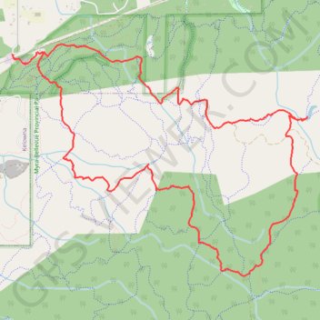
Myra-Bellevue Park hiking trails
foot, hike, path, loop
- Distance: 7.7 mi
- Elevation gain: 474 m
- Maximum elevation: 944 m
- Elevation loss: 476 m
- Minimum elevation: 514 m
- Moving time: 2 h 24 m
- Moving speed: 3.2 mph
- Maximum speed: 25.4 mph
- Total time: 2 h 47 m
- Global speed: 2.8 mph
Interactive trail map
Thank you for supporting this site ❤️
Make a donation
Make a donation
Gear up for your next adventure:
As an Amazon Associate, this site earns from qualifying purchases at no extra cost to you.
Trail profile
- Distance: 7.7 mi
- Elevation gain: 474 m
- Maximum elevation: 944 m
- Elevation loss: 476 m
- Minimum elevation: 514 m
- Moving time: 2 h 24 m
- Moving speed: 3.2 mph
- Maximum speed: 25.4 mph
- Total time: 2 h 47 m
- Global speed: 2.8 mph
Thank you for supporting this site ❤️
Make a donation
Make a donation
Gear up for your next adventure:
As an Amazon Associate, this site earns from qualifying purchases at no extra cost to you.
About this trail
Name: Myra-Bellevue Park hiking trails trail, distance, elevation, map, profile, GPS track
Coordinates: 49.79167 -119.44639 49.81341 -119.40334
Thank you for supporting this site ❤️
Make a donation
Make a donation
Gear up for your next adventure:
As an Amazon Associate, this site earns from qualifying purchases at no extra cost to you.
Other hiking, mountain biking, running and outdoor activity trails
Click on a trail to view its statistics, map and profile.