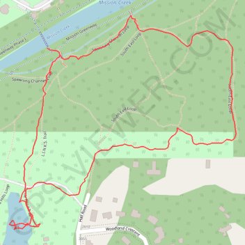
Mission Creek Park loop
foot, path, hiking, walk
- Distance: 1.2 mi
- Elevation gain: 44 m
- Maximum elevation: 413 m
- Elevation loss: 47 m
- Minimum elevation: 376 m
- Moving time: 26 m 40 s
- Moving speed: 2.8 mph
- Maximum speed: 7.3 mph
- Total time: 31 m 16 s
- Global speed: 2.4 mph
Interactive trail map
Trail profile
- Distance: 1.2 mi
- Elevation gain: 44 m
- Maximum elevation: 413 m
- Elevation loss: 47 m
- Minimum elevation: 376 m
- Moving time: 26 m 40 s
- Moving speed: 2.8 mph
- Maximum speed: 7.3 mph
- Total time: 31 m 16 s
- Global speed: 2.4 mph
About this trail
Name: Mission Creek Park loop trail, distance, elevation, map, profile, GPS track
Coordinates: 49.87311 -119.43140 49.87724 -119.42462
Other hiking, mountain biking, running and outdoor activity trails
Click on a trail to view its statistics, map and profile.