Thank you for supporting this site ❤️
Make a donation
Make a donation
Gear up for your next adventure:
As an Amazon Associate, this site earns from qualifying purchases at no extra cost to you.
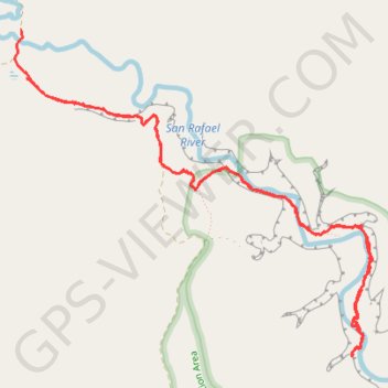
Fuller Bottom Little Grand Canyon San Rafael River
- Distance: 6.8 mi
- Elevation gain: 359 m
- Maximum elevation: 1,664 m
- Elevation loss: 361 m
- Minimum elevation: 1,597 m
- Moving time: 2 h 51 m
- Moving speed: 2.4 mph
- Maximum speed: 8.0 mph
- Total time: 3 h 23 m
- Global speed: 2.0 mph
Interactive trail map
Thank you for supporting this site ❤️
Make a donation
Make a donation
Gear up for your next adventure:
As an Amazon Associate, this site earns from qualifying purchases at no extra cost to you.
Trail profile
- Distance: 6.8 mi
- Elevation gain: 359 m
- Maximum elevation: 1,664 m
- Elevation loss: 361 m
- Minimum elevation: 1,597 m
- Moving time: 2 h 51 m
- Moving speed: 2.4 mph
- Maximum speed: 8.0 mph
- Total time: 3 h 23 m
- Global speed: 2.0 mph
Thank you for supporting this site ❤️
Make a donation
Make a donation
Gear up for your next adventure:
As an Amazon Associate, this site earns from qualifying purchases at no extra cost to you.
About this trail
Name: Fuller Bottom Little Grand Canyon San Rafael River trail, distance, elevation, map, profile, GPS track
Start: Little Wedge Road, Emery County, Utah, United States (39.11298 -110.85348)
End: Fuller Bottom Road, Emery County, Utah, United States (39.11632 -110.85401)
Coordinates: 39.09358 -110.85457 39.11635 -110.82253
Thank you for supporting this site ❤️
Make a donation
Make a donation
Gear up for your next adventure:
As an Amazon Associate, this site earns from qualifying purchases at no extra cost to you.