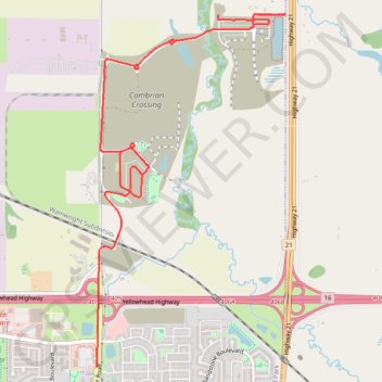
Cambrian Crossing
- Distance: 4.9 mi
- Elevation gain: 68 m
- Maximum elevation: 686 m
- Elevation loss: 37 m
- Minimum elevation: 651 m
- Moving time: 18 m 28 s
- Moving speed: 15.8 mph
- Maximum speed: 35.4 mph
- Total time: 18 m 28 s
- Global speed: 15.8 mph
Interactive trail map
Trail profile
- Distance: 4.9 mi
- Elevation gain: 68 m
- Maximum elevation: 686 m
- Elevation loss: 37 m
- Minimum elevation: 651 m
- Moving time: 18 m 28 s
- Moving speed: 15.8 mph
- Maximum speed: 35.4 mph
- Total time: 18 m 28 s
- Global speed: 15.8 mph
About this trail
Name: Cambrian Crossing trail, distance, elevation, map, profile, GPS track
End: Clover Bar Road, Sherwood Park, Strathcona County, Alberta, T8H 0P1, Canada (53.56485 -113.27121)
Coordinates: 53.56485 -113.27121 53.59223 -113.24666