Make a donation
Gear up for your next adventure:
As an Amazon Associate, this site earns from qualifying purchases at no extra cost to you.
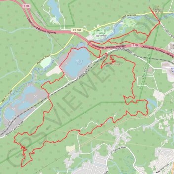
Allamuchy Mountain State Park
- Distance: 17.1 mi
- Elevation gain: 444 m
- Maximum elevation: 355 m
- Elevation loss: 444 m
- Minimum elevation: 192 m
- Moving time: 3 h 1 m
- Moving speed: 5.7 mph
- Maximum speed: 17.5 mph
- Total time: 3 h 13 m
- Global speed: 5.3 mph
Interactive trail map
Make a donation
Gear up for your next adventure:
As an Amazon Associate, this site earns from qualifying purchases at no extra cost to you.
Trail profile
- Distance: 17.1 mi
- Elevation gain: 444 m
- Maximum elevation: 355 m
- Elevation loss: 444 m
- Minimum elevation: 192 m
- Moving time: 3 h 1 m
- Moving speed: 5.7 mph
- Maximum speed: 17.5 mph
- Total time: 3 h 13 m
- Global speed: 5.3 mph
Make a donation
Gear up for your next adventure:
As an Amazon Associate, this site earns from qualifying purchases at no extra cost to you.
About this trail
Name: Allamuchy Mountain State Park trail, distance, elevation, map, profile, GPS track
Coordinates: 40.88106 -74.78582 40.92258 -74.73580
Make a donation
Gear up for your next adventure:
As an Amazon Associate, this site earns from qualifying purchases at no extra cost to you.
Other hiking, mountain biking, running and outdoor activity trails
Click on a trail to view its statistics, map and profile.
Allamuchy E-Mountain Bike Ride
United States > New Jersey > Morris County > Mount Olive
Allamuchy Mountain
Distance: 16.8 mi • Elevation gain: 544 m • Maximum elevation: 371 m
Stephens State Park
United States > New Jersey > Sussex County > Byram Township
Distance: 21.5 mi • Elevation gain: 688 m • Maximum elevation: 359 m
Best Of Deer Park
United States > New Jersey > Morris County > Mount Olive
Distance: 19.8 mi • Elevation gain: 621 m • Maximum elevation: 341 m