Dirty Harry's Balcony in Middle Fork Snoqualmie Natural Resources Conservation Area
Dirty Harry's Balcony, nestled within the Middle Fork Snoqualmie Natural Resources Conservation Area, offers hikers a rewarding journey through dense forests adorned with towering conifers and lush undergrowth. As you ascend the Dirty Harry's Peak Trail, remnants of the area's logging history, such as old equipment and rusted cables, can be spotted, adding a historical touch to the natural beauty. Upon reaching the Balcony, you're greeted with expansive views of the Snoqualmie River Valley and the surrounding Cascade Mountains, making the hike's challenges well worth the effort. #Hiking #Mountain #Forest #Overlook #Nature
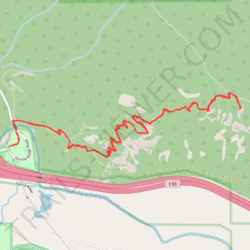
- Distance: 4.5 mi
- Elevation gain: 478 m
- Maximum elevation: 786 m
- Elevation loss: 477 m
- Minimum elevation: 400 m
- Moving time: 2 h 17 m
- Moving speed: 1.9 mph
- Maximum speed: 3.2 mph
- Total time: 2 h 36 m
- Global speed: 1.7 mph
Interactive trail map
Trail profile
- Distance: 4.5 mi
- Elevation gain: 478 m
- Maximum elevation: 786 m
- Elevation loss: 477 m
- Minimum elevation: 400 m
- Moving time: 2 h 17 m
- Moving speed: 1.9 mph
- Maximum speed: 3.2 mph
- Total time: 2 h 36 m
- Global speed: 1.7 mph
About this trail
Name: Dirty Harry's Balcony in Middle Fork Snoqualmie Natural Resources Conservation Area trail, distance, elevation, map, profile, GPS track
Coordinates: 47.43059 -121.63231 47.43478 -121.61015
Other hiking, mountain biking, running and outdoor activity trails
Click on a trail to view its statistics, map and profile.
Dirty Harry's Peak Trail in Middle Fork Snoqualmie Natural Resources Conservation Area
United States > Washington > King County
The Dirty Harry's Peak Trail offers a vigorous and rewarding hike through the Middle Fork Snoqualmie Natural Resources Conservation Area. The route begins by climbing steadily through dense forests, eventually breaking into rocky terrain with expansive views of the surrounding peaks and valleys. From the…
Distance: 8.0 mi • Elevation gain: 1,081 m • Maximum elevation: 1,392 m
Northern part of the Pacific Crest Trail (PCT)
United States > Oregon > Klamath County
Hike on the Pacific Crest National Scenic Trail from Crater Lake to Canada Border through Oregon and Washington along the Sierra Nevada and Cascade mountain ranges. #Hiking #Mountain #SierraNevada #Cascade #Nature #Forest #Park #PCT
Distance: 744.6 mi • Elevation gain: 44,308 m • Maximum elevation: 2,307 m
Dirty Harry's Peak Trail
United States > Washington > King County
Distance: 8.7 mi • Elevation gain: 1,096 m • Maximum elevation: 1,393 m