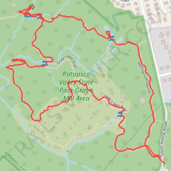
Gray's Mill Loop Trail in Patapsco Valley State Park
- Distance: 2.1 mi
- Elevation gain: 49 m
- Maximum elevation: 113 m
- Elevation loss: 48 m
- Minimum elevation: 80 m
- Moving time: 1 h 54 s
- Moving speed: 2.0 mph
- Maximum speed: 5.3 mph
- Total time: 1 h 34 m
- Global speed: 1.3 mph
Interactive trail map
Trail profile
- Distance: 2.1 mi
- Elevation gain: 49 m
- Maximum elevation: 113 m
- Elevation loss: 48 m
- Minimum elevation: 80 m
- Moving time: 1 h 54 s
- Moving speed: 2.0 mph
- Maximum speed: 5.3 mph
- Total time: 1 h 34 m
- Global speed: 1.3 mph
About this trail
Name: Gray's Mill Loop Trail in Patapsco Valley State Park trail, distance, elevation, map, profile, GPS track
Coordinates: 39.25519 -76.76462 39.26099 -76.75711
Other hiking, mountain biking, running and outdoor activity trails
Click on a trail to view its statistics, map and profile.
Patapsco Valley State Park Hilton Area Loop
United States > Maryland > Baltimore County > Catonsville
Distance: 4.3 mi • Elevation gain: 188 m • Maximum elevation: 123 m
Patapsco Valley State Park Hilton Area Loop
United States > Maryland > Baltimore County > Catonsville
Distance: 6.2 mi • Elevation gain: 251 m • Maximum elevation: 125 m
Patapsco Valley State Park trails
United States > Maryland > Baltimore County > Catonsville
Distance: 4.4 mi • Elevation gain: 129 m • Maximum elevation: 119 m
Patapsco Valley State Park Hilton Area Loop Hike
United States > Maryland > Baltimore County > Catonsville
Distance: 4.4 mi • Elevation gain: 181 m • Maximum elevation: 123 m
Patapsco Valley State Park Hilton Area
United States > Maryland > Baltimore County > Catonsville
Morning Loop Hike
Distance: 6.8 mi • Elevation gain: 234 m • Maximum elevation: 125 m
Patapsco Valley State Park
United States > Maryland > Baltimore County > Catonsville
Morning Loop Hike
Distance: 6.1 mi • Elevation gain: 320 m • Maximum elevation: 125 m
Scouting Old Ilchester
United States > Maryland > Howard County > Ilchester
Morning Hike
Distance: 4.9 mi • Elevation gain: 224 m • Maximum elevation: 108 m