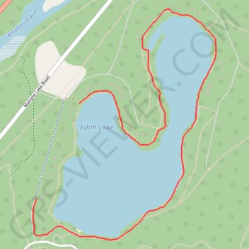
Import a GPX file

Edith Lake Loop

Jasper National Park. #Hiking #Edith #Loop #Jasper

  • Distance: 2.5 mi
  • Elevation gain: 31 m
  • Maximum elevation: 1,030 m
  • Elevation loss: 25 m
  • Minimum elevation: 1,020 m

Interactive trail map

Trail profile

  • Distance: 2.5 mi
  • Elevation gain: 31 m
  • Maximum elevation: 1,030 m
  • Elevation loss: 25 m
  • Minimum elevation: 1,020 m

About this trail

Name: Edith Lake Loop trail, distance, elevation, map, profile, GPS track

Start: Edith Lake Drive, Municipality of Jasper, Alberta, T0E 1E0, Canada (52.91415 -118.04448)

End: Edith Lake Drive, Municipality of Jasper, Alberta, T0E 1E0, Canada (52.90911 -118.04820)

Coordinates: 52.90694 -118.04850 52.91911 -118.03250

Gear up for your next adventure:

🗺️Scratch-off Peak Maps - Track your progress climbing Munros or Wainwrights
🧊Insulated Flasks - Keeps drinks hot or cold during hikes
🥾Hiking Boots - Waterproof and durable boots for long-distance hiking in the UK
🖼️Topographic Map Art - Decorative 3D-effect posters of famous UK peaks and regions
🔦Outdoor Torches - Reliable torches for night navigation

As an Amazon Associate, this site earns from qualifying purchases at no extra cost to you.