
Suffolk Coast Path #05 (Dunwich to Eastbridge)
- Distance: 10.9 mi
- Elevation gain: 133 m
- Maximum elevation: 27 m
- Elevation loss: 132 m
- Minimum elevation: 1 m
- Moving time: 4 h 1 m
- Moving speed: 2.7 mph
- Maximum speed: 7.6 mph
- Total time: 5 h 20 m
- Global speed: 2.0 mph
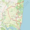
Interactive trail map
Trail profile
- Distance: 10.9 mi
- Elevation gain: 133 m
- Maximum elevation: 27 m
- Elevation loss: 132 m
- Minimum elevation: 1 m
- Moving time: 4 h 1 m
- Moving speed: 2.7 mph
- Maximum speed: 7.6 mph
- Total time: 5 h 20 m
- Global speed: 2.0 mph
About this trail
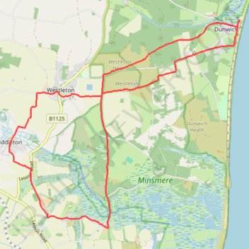
Name: Suffolk Coast Path #05 (Dunwich to Eastbridge) trail, distance, elevation, map, profile, GPS track
Coordinates: 52.23793 1.55904 52.27854 1.63286
Topography: East Suffolk topographic map, elevation, terrain
Other hiking, mountain biking, running and outdoor activity trails
Click on a trail to view its statistics, map and profile.
Eastbridge to Thorpeness loop hike - Suffolk Coast Path (SCP)
United Kingdom > England > Suffolk > East Suffolk > Leiston
Distance: 11.0 mi • Elevation gain: 84 m • Maximum elevation: 19 m
Suffolk Coast Path - Dunwich to Walberwick Loop
United Kingdom > England > Suffolk > East Suffolk > Dunwich
Distance: 13.9 mi • Elevation gain: 125 m • Maximum elevation: 22 m
Various tracks in Dunwich forest
United Kingdom > England > Suffolk > East Suffolk > Westleton
Distance: 10.0 mi • Elevation gain: 107 m • Maximum elevation: 23 m
Dunwich to Aldborough loop ride
United Kingdom > England > Suffolk > East Suffolk > Dunwich
Distance: 36.2 mi • Elevation gain: 352 m • Maximum elevation: 41 m