Thank you for supporting this site ❤️
Make a donation
Make a donation
Gear up for your next adventure:
As an Amazon Associate, this site earns from qualifying purchases at no extra cost to you.
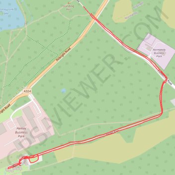
Henley Park
- Distance: 2.3 mi
- Elevation gain: 27 m
- Maximum elevation: 62 m
- Elevation loss: 26 m
- Minimum elevation: 43 m
- Moving time: 19 m 11 s
- Moving speed: 7.2 mph
- Maximum speed: 9.9 mph
- Total time: 19 m 11 s
- Global speed: 7.2 mph
Interactive trail map
Thank you for supporting this site ❤️
Make a donation
Make a donation
Gear up for your next adventure:
As an Amazon Associate, this site earns from qualifying purchases at no extra cost to you.
Trail profile
- Distance: 2.3 mi
- Elevation gain: 27 m
- Maximum elevation: 62 m
- Elevation loss: 26 m
- Minimum elevation: 43 m
- Moving time: 19 m 11 s
- Moving speed: 7.2 mph
- Maximum speed: 9.9 mph
- Total time: 19 m 11 s
- Global speed: 7.2 mph
Thank you for supporting this site ❤️
Make a donation
Make a donation
Gear up for your next adventure:
As an Amazon Associate, this site earns from qualifying purchases at no extra cost to you.
About this trail
Name: Henley Park trail, distance, elevation, map, profile, GPS track
Start: Henley Gate, Pirbright, Guildford, Surrey, England, GU24 0DH, United Kingdom (51.27372 -0.65506)
End: Henley Gate, Pirbright, Guildford, Surrey, England, GU24 0DH, United Kingdom (51.27405 -0.65565)
Coordinates: 51.26605 -0.66162 51.27405 -0.64904
Topography: Surrey topographic map, elevation, terrain
Thank you for supporting this site ❤️
Make a donation
Make a donation
Gear up for your next adventure:
As an Amazon Associate, this site earns from qualifying purchases at no extra cost to you.