More biking around Seattle
- Distance: 13.2 mi
- Elevation gain: 252 m
- Maximum elevation: 53 m
- Elevation loss: 219 m
- Minimum elevation: -1 m
Interactive trail map
Trail profile
- Distance: 13.2 mi
- Elevation gain: 252 m
- Maximum elevation: 53 m
- Elevation loss: 219 m
- Minimum elevation: -1 m
About this trail
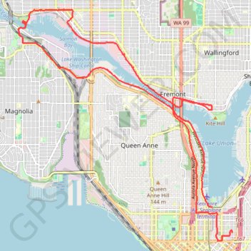
Name: More biking around Seattle trail, distance, elevation, map, profile, GPS track
Coordinates: 47.61844 -122.39960 47.66871 -122.33091
Other hiking, mountain biking, running and outdoor activity trails
Click on a trail to view its statistics, map and profile.
Queen Anne Greenbelt trails tracing
United States > Washington > King County > Seattle
West Queen Anne Loop
Distance: 4.3 mi • Elevation gain: 199 m • Maximum elevation: 101 m
Biking around Seattle
United States > Washington > King County > Seattle
Distance: 29.6 mi • Elevation gain: 407 m • Maximum elevation: 55 m