Bonita Lakes Loop Trail
The Bonita Lakes Loop Trail offers a peaceful hike through lush woodlands, with scenic views of three tranquil lakes. The trail provides a blend of gravel paths and forested sections, making it an enjoyable spot for walking, biking, or exploring with a leashed dog. As you follow the loop, you can experience gentle elevation changes while taking in the calm surroundings and abundant wildlife. The well-maintained trail, combined with workout stations and optional detours, makes it a versatile outdoor retreat for both casual and experienced hikers. #Hiking #Loop #Lake #Forest #Nature
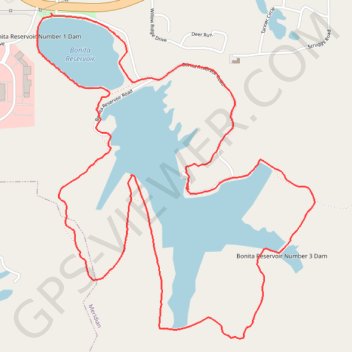
- Distance: 6.3 mi
- Elevation gain: 213 m
- Maximum elevation: 159 m
- Elevation loss: 212 m
- Minimum elevation: 96 m
- Moving time: 2 h 28 m
- Moving speed: 2.6 mph
- Maximum speed: 3.7 mph
- Total time: 2 h 50 m
- Global speed: 2.2 mph
Interactive trail map
Trail profile
- Distance: 6.3 mi
- Elevation gain: 213 m
- Maximum elevation: 159 m
- Elevation loss: 212 m
- Minimum elevation: 96 m
- Moving time: 2 h 28 m
- Moving speed: 2.6 mph
- Maximum speed: 3.7 mph
- Total time: 2 h 50 m
- Global speed: 2.2 mph
About this trail
Name: Bonita Lakes Loop Trail trail, distance, elevation, map, profile, GPS track
End: MS 19, Bonita, Meridian, Lauderdale County, Mississippi, 39301, United States (32.36343 -88.66579)
Coordinates: 32.34365 -88.66678 32.36343 -88.64683