Thank you for supporting this site ❤️
Make a donation
Make a donation
Gear up for your next adventure:
As an Amazon Associate, this site earns from qualifying purchases at no extra cost to you.
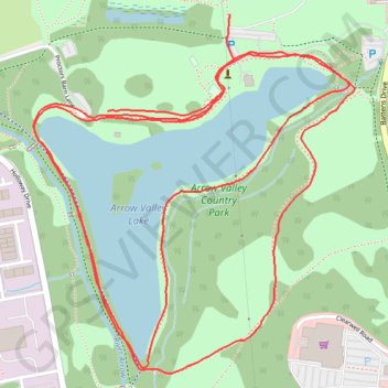
Arrow Valley Country Park Loop
- Distance: 3.1 mi
- Elevation gain: 24 m
- Maximum elevation: 86 m
- Elevation loss: 25 m
- Minimum elevation: 77 m
- Moving time: 31 m 12 s
- Moving speed: 6.0 mph
- Maximum speed: 10.2 mph
- Total time: 31 m 12 s
- Global speed: 6.0 mph
Interactive trail map
Thank you for supporting this site ❤️
Make a donation
Make a donation
Gear up for your next adventure:
As an Amazon Associate, this site earns from qualifying purchases at no extra cost to you.
Trail profile
- Distance: 3.1 mi
- Elevation gain: 24 m
- Maximum elevation: 86 m
- Elevation loss: 25 m
- Minimum elevation: 77 m
- Moving time: 31 m 12 s
- Moving speed: 6.0 mph
- Maximum speed: 10.2 mph
- Total time: 31 m 12 s
- Global speed: 6.0 mph
Thank you for supporting this site ❤️
Make a donation
Make a donation
Gear up for your next adventure:
As an Amazon Associate, this site earns from qualifying purchases at no extra cost to you.
About this trail
Name: Arrow Valley Country Park Loop trail, distance, elevation, map, profile, GPS track
Coordinates: 52.30110 -1.91630 52.30795 -1.90628
Topography: Worcestershire topographic map, elevation, terrain
Thank you for supporting this site ❤️
Make a donation
Make a donation
Gear up for your next adventure:
As an Amazon Associate, this site earns from qualifying purchases at no extra cost to you.