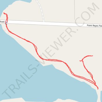
Hike near Nicasio Reservoir
- Distance: 1.1 mi
- Elevation gain: 30 m
- Maximum elevation: 77 m
- Elevation loss: 29 m
- Minimum elevation: 51 m
- Moving time: 27 m 53 s
- Moving speed: 2.3 mph
- Maximum speed: 7.9 mph
- Total time: 33 m 37 s
- Global speed: 1.9 mph
Interactive trail map
Trail profile
- Distance: 1.1 mi
- Elevation gain: 30 m
- Maximum elevation: 77 m
- Elevation loss: 29 m
- Minimum elevation: 51 m
- Moving time: 27 m 53 s
- Moving speed: 2.3 mph
- Maximum speed: 7.9 mph
- Total time: 33 m 37 s
- Global speed: 1.9 mph
About this trail
Name: Hike near Nicasio Reservoir trail, distance, elevation, map, profile, GPS track
Start: Point Reyes Petaluma Road, Marin County, California, United States (38.09213 -122.74471)
End: Point Reyes Petaluma Road, Marin County, California, United States (38.09227 -122.74468)
Coordinates: 38.08935 -122.74485 38.09272 -122.73959
Other hiking, mountain biking, running and outdoor activity trails
Click on a trail to view its statistics, map and profile.
Point Reyes Loop
United States > California > Marin County > Mill Valley
Distance: 62.3 mi • Elevation gain: 1,900 m • Maximum elevation: 236 m