Thank you for supporting this site ❤️
Make a donation
Make a donation
Gear up for your next adventure:
As an Amazon Associate, this site earns from qualifying purchases at no extra cost to you.
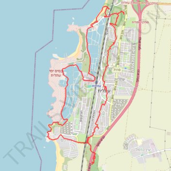
Historical trail run around Atlit
- Distance: 10.2 mi
- Elevation gain: 97 m
- Maximum elevation: 28 m
- Elevation loss: 97 m
- Minimum elevation: -1 m
- Moving time: 2 h 24 m
- Moving speed: 4.2 mph
- Maximum speed: 8.6 mph
- Total time: 2 h 30 m
- Global speed: 4.1 mph
Interactive trail map
Thank you for supporting this site ❤️
Make a donation
Make a donation
Gear up for your next adventure:
As an Amazon Associate, this site earns from qualifying purchases at no extra cost to you.
Trail profile
- Distance: 10.2 mi
- Elevation gain: 97 m
- Maximum elevation: 28 m
- Elevation loss: 97 m
- Minimum elevation: -1 m
- Moving time: 2 h 24 m
- Moving speed: 4.2 mph
- Maximum speed: 8.6 mph
- Total time: 2 h 30 m
- Global speed: 4.1 mph
Thank you for supporting this site ❤️
Make a donation
Make a donation
Gear up for your next adventure:
As an Amazon Associate, this site earns from qualifying purchases at no extra cost to you.
About this trail
Name: Historical trail run around Atlit trail, distance, elevation, map, profile, GPS track
Coordinates: 32.67347 34.92645 32.71043 34.94794
Thank you for supporting this site ❤️
Make a donation
Make a donation
Gear up for your next adventure:
As an Amazon Associate, this site earns from qualifying purchases at no extra cost to you.