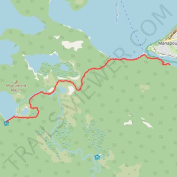
Manapouri to Hope Arm Hut
- Distance: 5.5 mi
- Elevation gain: 147 m
- Maximum elevation: 247 m
- Elevation loss: 149 m
- Minimum elevation: 184 m
- Moving time: 2 h 22 m
- Moving speed: 2.3 mph
- Maximum speed: 3.3 mph
- Total time: 2 h 32 m
- Global speed: 2.2 mph
Interactive trail map
Trail profile
- Distance: 5.5 mi
- Elevation gain: 147 m
- Maximum elevation: 247 m
- Elevation loss: 149 m
- Minimum elevation: 184 m
- Moving time: 2 h 22 m
- Moving speed: 2.3 mph
- Maximum speed: 3.3 mph
- Total time: 2 h 32 m
- Global speed: 2.2 mph
About this trail
Name: Manapouri to Hope Arm Hut trail, distance, elevation, map, profile, GPS track
Coordinates: -45.58989 167.54149 -45.56885 167.61411
Other hiking, mountain biking, running and outdoor activity trails
Click on a trail to view its statistics, map and profile.
Hope Arm Hut to Manapouri
New Zealand > Southland > Southland District > Fiordland Community
Distance: 5.5 mi • Elevation gain: 151 m • Maximum elevation: 247 m