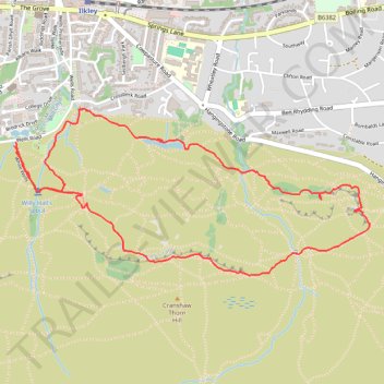
White Wells Loop
- Distance: 3.1 mi
- Elevation gain: 230 m
- Maximum elevation: 317 m
- Elevation loss: 232 m
- Minimum elevation: 143 m
- Moving time: 1 h 29 m
- Moving speed: 2.1 mph
- Maximum speed: 3.6 mph
- Total time: 2 h 1 m
- Global speed: 1.5 mph
Interactive trail map
Trail profile
- Distance: 3.1 mi
- Elevation gain: 230 m
- Maximum elevation: 317 m
- Elevation loss: 232 m
- Minimum elevation: 143 m
- Moving time: 1 h 29 m
- Moving speed: 2.1 mph
- Maximum speed: 3.6 mph
- Total time: 2 h 1 m
- Global speed: 1.5 mph
About this trail
Name: White Wells Loop trail, distance, elevation, map, profile, GPS track
Coordinates: 53.91362 -1.82637 53.92040 -1.80174
Topography: Bradford topographic map, elevation, terrain
Other hiking, mountain biking, running and outdoor activity trails
Click on a trail to view its statistics, map and profile.
Otley - Draughton/Skipton Moor and return
United Kingdom > England > Leeds
Distance: 25.7 mi • Elevation gain: 456 m • Maximum elevation: 318 m