Donderdag 29 mei 2025 - 20 km
<p>Van Leopold III-laan 16, 8900 Ieper, België<br/>
Naar Leopold III-laan 16, 8900 Ieper, België</p>
<p>Routering Wandel - mooiste, Manueel</p>
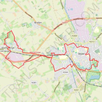
- Distance: 12.5 mi
- Elevation gain: 70 m
- Maximum elevation: 30 m
- Elevation loss: 71 m
- Minimum elevation: 14 m
Interactive trail map
Trail profile
- Distance: 12.5 mi
- Elevation gain: 70 m
- Maximum elevation: 30 m
- Elevation loss: 71 m
- Minimum elevation: 14 m
About this trail
Name: Donderdag 29 mei 2025 - 20 km trail, distance, elevation, map, profile, GPS track
Start: Leopold III-laan, Ypres, Ieper, West Flanders, Flanders, 8900, Belgium (50.84617 2.89408)
End: Kanteelpad, Ypres, Ieper, West Flanders, Flanders, 8900, Belgium (50.84619 2.89414)
Coordinates: 50.84253 2.81832 50.86453 2.89887
Other hiking, mountain biking, running and outdoor activity trails
Click on a trail to view its statistics, map and profile.
Stadswandelroute_ieper
Belgium > West Flanders > Ieper > Ypres
Distance: 4.1 mi • Elevation gain: 21 m • Maximum elevation: 26 m
Gent-Wevelgem Cyclo 2022 - 90km
Belgium > West Flanders > Kortrijk > Wevelgem
Distance: 58.4 mi • Elevation gain: 485 m • Maximum elevation: 151 m