Sandia Mountain Wilderness Hike - Osha Spring Trail
- Distance: 8.7 mi
- Elevation gain: 795 m
- Maximum elevation: 2,771 m
- Elevation loss: 794 m
- Minimum elevation: 1,985 m
- Moving time: 4 h 49 s
- Moving speed: 2.2 mph
- Maximum speed: 3.7 mph
- Total time: 5 h 9 m
- Global speed: 1.7 mph
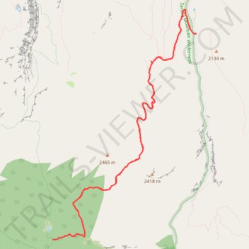
Interactive trail map
Trail profile
- Distance: 8.7 mi
- Elevation gain: 795 m
- Maximum elevation: 2,771 m
- Elevation loss: 794 m
- Minimum elevation: 1,985 m
- Moving time: 4 h 49 s
- Moving speed: 2.2 mph
- Maximum speed: 3.7 mph
- Total time: 5 h 9 m
- Global speed: 1.7 mph
About this trail
Name: Sandia Mountain Wilderness Hike - Osha Spring Trail trail, distance, elevation, map, profile, GPS track
Start: NM 165, Cooper LS Ranch, Sandoval County, New Mexico, United States (35.27535 -106.40913)
End: NM 165, Cooper LS Ranch, Sandoval County, New Mexico, United States (35.27529 -106.40915)
Coordinates: 35.24436 -106.43552 35.27898 -106.40913