Thank you for supporting this site ❤️
Make a donation
Make a donation
Gear up for your next adventure:
As an Amazon Associate, this site earns from qualifying purchases at no extra cost to you.
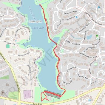
Section of Lake Lynn Trail
- Distance: 1.8 mi
- Elevation gain: 27 m
- Maximum elevation: 113 m
- Elevation loss: 28 m
- Minimum elevation: 100 m
- Moving time: 42 m 25 s
- Moving speed: 2.6 mph
- Maximum speed: 3.6 mph
- Total time: 49 m 3 s
- Global speed: 2.2 mph
Interactive trail map
Thank you for supporting this site ❤️
Make a donation
Make a donation
Gear up for your next adventure:
As an Amazon Associate, this site earns from qualifying purchases at no extra cost to you.
Trail profile
- Distance: 1.8 mi
- Elevation gain: 27 m
- Maximum elevation: 113 m
- Elevation loss: 28 m
- Minimum elevation: 100 m
- Moving time: 42 m 25 s
- Moving speed: 2.6 mph
- Maximum speed: 3.6 mph
- Total time: 49 m 3 s
- Global speed: 2.2 mph
Thank you for supporting this site ❤️
Make a donation
Make a donation
Gear up for your next adventure:
As an Amazon Associate, this site earns from qualifying purchases at no extra cost to you.
About this trail
Name: Section of Lake Lynn Trail trail, distance, elevation, map, profile, GPS track
Coordinates: 35.87204 -78.69863 35.88110 -78.69567
Thank you for supporting this site ❤️
Make a donation
Make a donation
Gear up for your next adventure:
As an Amazon Associate, this site earns from qualifying purchases at no extra cost to you.