Wilson Mountain Summit Loop (Red Rock-Secret Mountain Wilderness)
Loop hike on Wilson Mountain via Wilson Mountain Trail, Sedona Overlook and Canyon Overlook in the Red Rock-Secret Mountain Wilderness. #Hiking #Loop #Mountain #Nature #Overlook #Forest #Wilderness
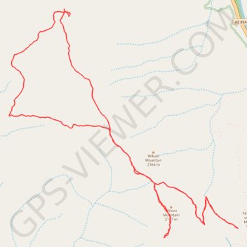
- Distance: 6.7 mi
- Elevation gain: 418 m
- Maximum elevation: 2,138 m
- Elevation loss: 418 m
- Minimum elevation: 1,912 m
- Moving time: 3 h 1 m
- Moving speed: 2.2 mph
- Maximum speed: 3.5 mph
- Total time: 3 h 34 m
- Global speed: 1.9 mph
Interactive trail map
Trail profile
- Distance: 6.7 mi
- Elevation gain: 418 m
- Maximum elevation: 2,138 m
- Elevation loss: 418 m
- Minimum elevation: 1,912 m
- Moving time: 3 h 1 m
- Moving speed: 2.2 mph
- Maximum speed: 3.5 mph
- Total time: 3 h 34 m
- Global speed: 1.9 mph
About this trail
Name: Wilson Mountain Summit Loop (Red Rock-Secret Mountain Wilderness) trail, distance, elevation, map, profile, GPS track
Start: North Wilson Trail, Coconino County, Arizona, United States (34.91043 -111.74100)
End: Wilson Mountain Trail, Coconino County, Arizona, United States (34.91045 -111.74104)
Coordinates: 34.90948 -111.76798 34.93162 -111.74100