Looking Glass Rock Trail in Pisgah National Forest
The Looking Glass Rock Trail offers an engaging and moderately strenuous hike with spectacular mountain views. Starting near a gentle stream, the path leads through lush rhododendron and laurel tunnels, eventually bringing you to a rocky clearing used as a helicopter pad. From there, the trail climbs further to the summit, where the views from Upper Looking Glass Cliffs are breathtaking, giving hikers a close-up view of the surrounding Pisgah National Forest. #Hiking #Mountain #Cliff #Overlook #Forest #Nature
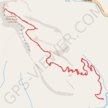
- Distance: 6.0 mi
- Elevation gain: 543 m
- Maximum elevation: 1,192 m
- Elevation loss: 547 m
- Minimum elevation: 713 m
- Moving time: 3 h 24 m
- Moving speed: 1.8 mph
- Maximum speed: 5.3 mph
- Total time: 4 h 34 m
- Global speed: 1.3 mph
Interactive trail map
Trail profile
- Distance: 6.0 mi
- Elevation gain: 543 m
- Maximum elevation: 1,192 m
- Elevation loss: 547 m
- Minimum elevation: 713 m
- Moving time: 3 h 24 m
- Moving speed: 1.8 mph
- Maximum speed: 5.3 mph
- Total time: 4 h 34 m
- Global speed: 1.3 mph
About this trail
Name: Looking Glass Rock Trail in Pisgah National Forest trail, distance, elevation, map, profile, GPS track
Start: Looking Glass Rock Trail, Transylvania County, North Carolina, United States (35.29095 -82.77685)
Coordinates: 35.29095 -82.79481 35.30446 -82.77656
Other hiking, mountain biking, running and outdoor activity trails
Click on a trail to view its statistics, map and profile.
Looking Glass Rock Trail in Pisgah National Forest
United States > North Carolina > Transylvania County
The Looking Glass Rock Trail in Pisgah National Forest offers a rewarding, moderately challenging hike with spectacular vistas. As you ascend, you'll pass through shaded forests, cross a stream, and encounter sections lined with rhododendron and mountain laurel, especially vibrant in spring. Once at the…
Distance: 2.7 mi • Elevation gain: 506 m • Maximum elevation: 1,192 m
Looking Glass Rock Trail in Pisgah National Forest
United States > North Carolina > Transylvania County
The Looking Glass Rock Trail in Pisgah National Forest offers an awe-inspiring hiking experience, leading trekkers through lush forests and rocky terrain. As you ascend, you'll be treated to panoramic views of the surrounding Blue Ridge Mountains, the Davidson River Valley, dense woods, and the iconic Looking…
Distance: 6.0 mi • Elevation gain: 585 m • Maximum elevation: 1,192 m