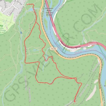
Mount Minsi Loop Trail from Lenape Lake via Appalachian Trail, Lookout Rock and Lake Road in Delaware Water Gap National Recreation Area
The Mount Minsi Loop Trail is a rewarding hiking experience featuring diverse landscapes and breathtaking viewpoints. As you ascend, the trail reveals stunning vistas such as the dramatic Lookout Rock and the expansive views from Minsi Lookout, which showcases the winding Delaware River and Mount Tammany across the way. The trail's combination of rocky paths, lush rhododendron tunnels, and serene streams, along with its historical elements like the remnants of an old fire tower, make this hike a memorable adventure for nature lovers and photographers alike. #Hiking #Loop #Overlook #Mountain #River #Forest #Nature
- Distance: 4.8 mi
- Elevation gain: 348 m
- Maximum elevation: 439 m
- Elevation loss: 347 m
- Minimum elevation: 153 m
- Moving time: 2 h 31 m
- Moving speed: 1.9 mph
- Maximum speed: 4.7 mph
- Total time: 2 h 41 m
- Global speed: 1.8 mph
Interactive trail map
Trail profile
- Distance: 4.8 mi
- Elevation gain: 348 m
- Maximum elevation: 439 m
- Elevation loss: 347 m
- Minimum elevation: 153 m
- Moving time: 2 h 31 m
- Moving speed: 1.9 mph
- Maximum speed: 4.7 mph
- Total time: 2 h 41 m
- Global speed: 1.8 mph
About this trail
Name: Mount Minsi Loop Trail from Lenape Lake via Appalachian Trail, Lookout Rock and Lake Road in Delaware Water Gap National Recreation Area trail, distance, elevation, map, profile, GPS track
Coordinates: 40.95884 -75.14299 40.97978 -75.12673
Other hiking, mountain biking, running and outdoor activity trails
Click on a trail to view its statistics, map and profile.
Mount Tammany Loop via Red Dot Trail, Delaware River Overlook and Blue Blaze in Worthington State Forest
United States > New Jersey > Warren County > Hardwick Township > Dunnfield
The Mount Tammany Loop offers a captivating hiking experience with its stunning panoramic views of the Delaware River and the surrounding landscapes. The ascent via the Red Dot Trail features rocky terrain and steep inclines, rewarding hikers with scenic overlooks, particularly the dramatic vistas of Mount…
Distance: 3.5 mi • Elevation gain: 365 m • Maximum elevation: 458 m