High Rocks Loop Trails in Ralph Stover State Park
The High Rocks Loop Trail offers a delightful hiking experience characterized by stunning views of the Tohickon Creek and its surrounding landscapes. Along the route, hikers can enjoy the unique geological features, including towering cliffs that attract rock climbers, as well as the tranquil sound of flowing water from nearby streams. This trail provides a great mix of scenic overlooks and forested areas, making it a popular choice for both outdoor enthusiasts and families looking to connect with nature. #Hiking #Loop #Rock #Cliff #River #Forest #Nature
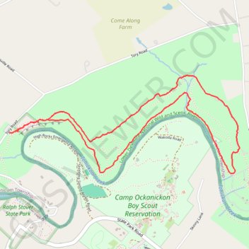
- Distance: 3.6 mi
- Elevation gain: 161 m
- Maximum elevation: 130 m
- Elevation loss: 165 m
- Minimum elevation: 64 m
- Moving time: 1 h 19 m
- Moving speed: 2.7 mph
- Maximum speed: 6.2 mph
- Total time: 1 h 26 m
- Global speed: 2.5 mph
Interactive trail map
Trail profile
- Distance: 3.6 mi
- Elevation gain: 161 m
- Maximum elevation: 130 m
- Elevation loss: 165 m
- Minimum elevation: 64 m
- Moving time: 1 h 19 m
- Moving speed: 2.7 mph
- Maximum speed: 6.2 mph
- Total time: 1 h 26 m
- Global speed: 2.5 mph
About this trail
Name: High Rocks Loop Trails in Ralph Stover State Park trail, distance, elevation, map, profile, GPS track
Coordinates: 40.43798 -75.10046 40.44494 -75.07898