Make a donation
Gear up for your next adventure:
As an Amazon Associate, this site earns from qualifying purchases at no extra cost to you.
Battle Park Loop
- Distance: 2.4 mi
- Elevation gain: 28 m
- Maximum elevation: 36 m
- Elevation loss: 28 m
- Minimum elevation: 20 m
- Moving time: 49 m 15 s
- Moving speed: 3.0 mph
- Maximum speed: 5.9 mph
- Total time: 50 m 9 s
- Global speed: 2.9 mph
Interactive trail map
Make a donation
Gear up for your next adventure:
As an Amazon Associate, this site earns from qualifying purchases at no extra cost to you.
Trail profile
- Distance: 2.4 mi
- Elevation gain: 28 m
- Maximum elevation: 36 m
- Elevation loss: 28 m
- Minimum elevation: 20 m
- Moving time: 49 m 15 s
- Moving speed: 3.0 mph
- Maximum speed: 5.9 mph
- Total time: 50 m 9 s
- Global speed: 2.9 mph
Make a donation
Gear up for your next adventure:
As an Amazon Associate, this site earns from qualifying purchases at no extra cost to you.
About this trail
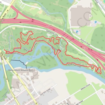
Name: Battle Park Loop trail, distance, elevation, map, profile, GPS track
Coordinates: 35.95958 -77.80493 35.96348 -77.79401
Make a donation
Gear up for your next adventure:
As an Amazon Associate, this site earns from qualifying purchases at no extra cost to you.
Other hiking, mountain biking, running and outdoor activity trails
Click on a trail to view its statistics, map and profile.
Rocky Mount Greenway: Battle Park to Martin Luther King Park
United States > North Carolina > Nash County > Rocky Mount > Swelton Heights
Distance: 2.9 mi • Elevation gain: 34 m • Maximum elevation: 37 m
Battle Park Loop
United States > North Carolina > Nash County > Rocky Mount > Swelton Heights
Distance: 3.9 mi • Elevation gain: 38 m • Maximum elevation: 37 m